
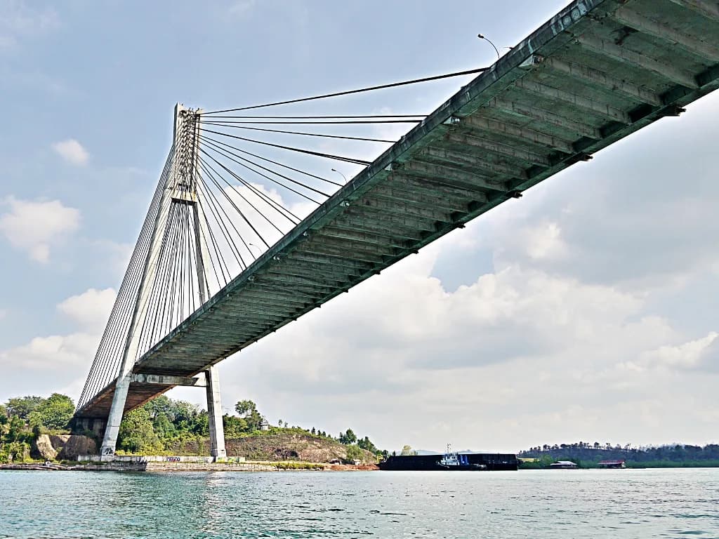
Barelang Bridge, Batam: Visiting the Jembatan Barelang Chain
Barelang Bridge is a chain of six bridges, not a single span, and the one most visitors mean is Bridge I, the Tengku Fisabilillah, about 35 kilometers from Batam city. Give the main span 30 to 60 minutes for photos and vendors, or set aside a half day if you want to drive the full chain on Jalan Trans Barelang. This guide covers where the bridge sits, how to reach it from Nagoya, what there is to see along the way, and which nearby stops are worth adding.
The distance from Batam's hotel districts is the factor that decides whether this fits into a shopping afternoon or needs its own block of time, so read the drive section before you commit. Costs, hours and access are listed below with the source that publishes them, and anything that changes without notice is flagged rather than guessed.
Six bridges, one name: what the Barelang chain actually is
The name is a contraction of Batam, Rempang and Galang, the islands the crossings connect, and the chain also touches Tonton and Nipah along the way. Travelers routinely say "Barelang Bridge" when they mean the first and largest crossing, so confirm with your driver that Bridge I is the stop you want rather than any of the later spans.
Bridge I, officially Tengku Fisabilillah, spans 642 meters and is the longest of the six, connecting Batam Island to Tonton Island. Its cable-stayed profile draws a comparison to the Golden Gate Bridge in traveler accounts, a visual shorthand rather than a claim about size or rank.
The later bridges carry Jalan Trans Barelang across Rempang and on to Galang, so a full drive takes you well past the postcard view into quieter island terrain. If your time in Batam is short, treat Bridge I as the destination and the rest of the chain as a bonus rather than a requirement.
Where the bridge sits and why the distance matters
The address listed for the bridge is Jalan Trans Barelang, Sembulang, Galang, Kota Batam, Kepulauan Riau, and the main span is roughly 35 kilometers from Batam city. That puts it on the far side of the island from Nagoya, Batam Center and the ferry terminals, so it does not work as a quick stop between mall visits.
Plan the crossing as the anchor of a half day and build the rest of your outing around it, rather than squeezing it into the tail end of an afternoon. Traffic across Batam can stretch the drive in either direction, so leaving a buffer is more useful than a precise arrival time.
Getting there from Nagoya and around the island
The sources consulted describe no public transport to the bridge, so most visitors hire a private driver for the round trip or ride a scooter if they are comfortable with a long, exposed run. For a group of two or more, a driver also solves the parking and turnaround question at the photo platform. Rates vary by operator and season, so ask your hotel or a licensed operator for a quote rather than relying on a figure quoted online.
The alternative is to join an organized Batam day tour that includes the bridge, which trades flexibility for a fixed schedule. Tour listings for the bridge appear on booking platforms, but check what a given itinerary actually stops at before you book.
Once you are on Jalan Trans Barelang the road runs across the chain, so the driving itself is part of the visit rather than dead time. Bring small change for roadside vendors and keep your return trip in mind if you are riding a scooter, since the distance makes a late start risky.
At Bridge I: the photo platform, the vendors and the view
Bridge I has a viewing platform where people stop to photograph the cables and the water below, and travelers report staff on hand offering photo services at the first bridge. Expect a short walk from where a driver parks, plus the usual roadside vendors selling grilled corn, fresh coconut water and souvenirs.
The span carries traffic, so the views come from the platform and the approach rather than from standing in a lane. Sunset is the most photographed window, when the light turns and the cables catch color, and it is also when the platform is busiest.
If you want an uncrowded frame, the earlier afternoon light still reads well and the vendors are less pressed. Weekend afternoons draw local day-trippers, so a weekday visit is the easier choice when your schedule allows it.
Going beyond Bridge I along the chain
Travelers often rate the second bridge as the better place to stop for open views and a breeze, since it is quieter than the first span and looks back toward it. Pulling over there adds perhaps 20 minutes and gives you a different angle on the water and the islands.
Continuing across Rempang toward Galang turns the outing into a road trip, with the bridges marking progress between islands. This is the version to choose if you have a driver for the afternoon and no fixed lunch booking waiting back in town.
Some itineraries combine the bridge with nearby island stops or a seafood meal, and HARRIS Resort Barelang Batam plus Nipah Island Resort are both listed on Jalan Trans Barelang. Decide in advance whether you are doing a photo stop or a loop, because the two plans need very different amounts of driving.
How much time to allow
The sightseeing time at the bridge itself is listed as 0.5 to 1 hour, which matches the reality of a photo stop, a drink from a vendor and a walk along the platform. That figure covers Bridge I only and does not count the drive from your hotel.
Add the road time from Nagoya or Batam Center and a Bridge I visit lands as a solid half day once you include the return. If you intend to cross several bridges, stop for seafood, or catch sunset, block out the whole afternoon and plan dinner near the water before driving back.
Cost and hours: what is published
Ticket price for the bridge is listed as free admission and opening times as year-round, 24 hours a day, per the same travel listing. Treat those as the listing's information rather than an operator announcement, since a public road bridge is not ticketed in the usual sense.
Parking arrangements, any photo-service charge and vendor prices are not published in the sources consulted, so confirm them on arrival rather than budgeting from a blog. Check current details with your driver or hotel the day before you go, especially if you plan to arrive after dark.
When to go: late afternoon, sunset and weekend crowds
Late afternoon into sunset is the strongest window, with cooler air and the light that makes the cable-stayed frame photogenic. The trade-off is company: the platform fills up around sunset and vendors do a brisk trade, so arrive early enough to claim a spot.
Midweek mornings are the quietest option and suit anyone who wants the span more or less to themselves. Weather across the Riau Islands shifts through the year, but no source here publishes a reliable dry or wet season pattern for the bridge, so watch the forecast in the days before your visit instead of planning around a month.
Nearby stops on Jalan Trans Barelang
Barelang Seafood Restaurant sits on the same road and is the obvious meal stop, with a view back toward the bridge and enough tables that walk-ins are usually fine. It appears in traveler accounts as one of the largest seafood spots in the area rather than as a reservation-only venue.
HARRIS Resort Barelang Batam is also listed on Jalan Trans Barelang, which makes it a sensible base if the bridge is the main reason for your Batam trip. Staying out here puts you close to the span for an early or sunset visit but farther from the ferry terminals and city dining.
If you are building a wider Batam day, the Masjid Raya Batam and the Nongsa Beach area sit on entirely different corners of the island and need their own transport planning. Neither pairs neatly with the bridge in a single tight afternoon.
Is the bridge worth the drive from Nagoya?
Yes, if you treat it as a half-day outing with a driver and time it for late afternoon, when the light and the views justify the 35-kilometer run. No, if your Batam trip is two nights of malls and food and you would be squeezing the bridge into a gap between other plans.
Book the transport first, confirm the published free access and 24-hour listing with your driver or hotel, and decide before you leave whether you are stopping at Bridge I or driving the chain. That single decision is what separates a relaxed photo stop from a rushed one.
Explore more Batam guides
Frequently Asked Questions
Is Batam part of Singapore?
No. Batam is Indonesian territory in the Riau Islands, and the Barelang Bridge is a domestic road link between Batam, Tonton, Nipah, Rempang and Galang. Travelers arriving by ferry from Singapore cross an international border, so bring your passport and allow time for immigration.
Is the Barelang Bridge the longest bridge in Indonesia?
The sources here do not support that claim. What is documented is that Bridge I, the Tengku Fisabilillah, is the longest of the six spans in the Barelang chain at 642 meters. Treat any wider ranking claim with caution and check a current reference before repeating it.